
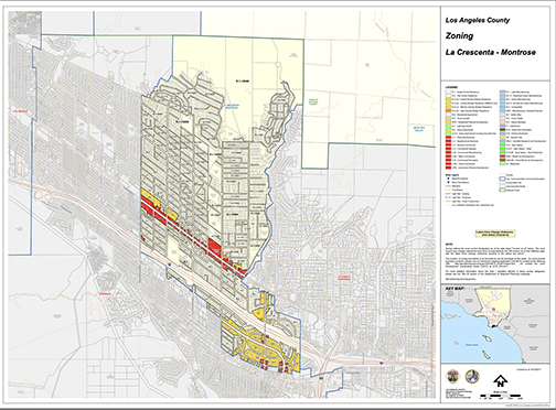
Map from LA County Planning
By Mikaela STONE
On Tuesday, the Los Angeles County Board of Supervisors approved the West San Gabriel Proposed Land Use Policy and Zoning Plan. This land use plan will replace the Altadena Community Plan adopted in 1986. The plan will affect residents in unincorporated Los Angeles County portions of Altadena, East Pasadena-East San Gabriel, Kinneloa Mesa, La Crescenta-Montrose, San Pasqual, South San Gabriel, South Monrovia Islanda, South El Monte Island and Whittier Narrows. The policy plans to use the next 20 years to increase walkability, conservation of wildlife and old oaks, and increase traffic to small businesses. The plan is the result of 15 years of community outreach and research.
No actual demolition or construction of buildings come with the plan. The change is in law only. The passage also does not change income taxes on already purchased properties. The plan will not increase density in high fire risk locations. The plan’s creation of wildlife crossings and the direction of plant growth away from high density locations are intended to preserve both human and animal life.
While supporters look forward to these changes, many oppose the possibility of an increased population within these areas, fearing traffic will worsen and strain may be placed on resources. The zoning plan chose to increase house limits near places with public transportation in hopes to mitigate this. One critical citizen argued that he planned to build multi-generational houses for his family on his land, and would now be restricted due to his property being zoned for fewer housing units.
Kathryn Barger celebrated the plan’s “bottom up approach” by including regional planning groups within each community to focus on what each individual community needed. She expressed frustration with the state’s efforts to facilitate this from the top down.
“Despite our county’s efforts to complete the housing element update on time a few years ago, the state’s Dept. of Housing and Community Development was understaffed and unable to complete their review in a timely manner,” she said. She noted that it was only due to regional committees that legislation was able to bring the county into compliance.
Changes that will directly affect La Crescenta-Montrose include an increase of zoning from nine dwelling units to 18 per net acre along Montrose Avenue near where it intersects with Raymond Avenue. Houses close to the intersection of La Crescenta Avenue and Foothill Boulevard will also be increased from nine to 18 dwelling units per net acre. A small plot off of Ocean View Boulevard and Foothill Boulevard will be rezoned from nine to 30 dwelling units per net acre. A large strip of land where Foothill Boulevard turns into Cloud Avenue will be changed from commercial use to mixed use. A plot of land off of Ocean View Boulevard between Honolulu Avenue and the 210 Freeway will be changed from commercial use to mixed use. A triangle of land near Sanborn Avenue and Glenwood Avenue will be zoned from nine to 19 du/net ac. The northern most end of Goss Canyon Avenue will be zoned for water. All property owners on Foothill are advised to check whether their land has been rezoned to mixed use development. Three plots near the intersection of Mary Street and La Crescenta Avenue have been upped from single family residences to two-family residences. A property on the east most side of Barton Lane increased from single family residents to triple family residents.
County Board Approves West San Gabriel Proposed Land Use Policy and Zoning Plan added by CV Weekly on
View all posts by CV Weekly →