
By forces seemingly antagonistic and destructive Nature accomplishes her beneficent designs now a flood of fire, now a flood of ice, now a flood of water; and again in the fullness of time an outburst of organic life. ~ John Muir
The skies are a color of blue in which only autumn presents. Daytime temperatures are not too hot nor too cold – perfect! The evening hours have grown dark and not as dog walking-friendly. Wasn’t it just about two weeks ago in which 1.50 inches of rain fell over the Crescenta Valley? And parts of northern California flooded?
During mild dry winters, like the ones we’ve experienced for the past two years, it’s easy to forget the Los Angeles basin has also seen its share of extreme flooding. In fact, intense rainfall, flash floods and their associated debris flows are part of the region’s normal climatic cycle.
Flooding occurs in Southern California because of an uneven landscape. Within a mere 70-mile distance, the elevation soars from sea level at the beaches to peaks of over 10,000 feet in the San Gabriel Mountains. Water flows downhill fast. Our local historian Mike Lawler often tells of the New Year’s Eve flood in 1934. Just four years later, history was to repeat itself … on a grander scale.
A particularly calamitous example of such flooding took place in late February and early March of 1938. The greater Los Angeles area was hit by two massive storms (totaling 33 inches at a nearby peak). The first storm was a cold one; the second was tropical and warm causing much of the existing snowpack to melt, which added to the floodwaters.
The falling rainwater combined with torrents of water cascading down mountain canyons to overwhelm the Los Angeles, San Gabriel and Santa Ana rivers and numerous smaller rivers and creeks. The resulting floodwaters inundated much of the Southland.
At least 115 people lost their lives. The water’s force and resulting mud brought widespread destruction to homes, railroad lines, farms and ranches, bridges, roads and power lines. Several small towns east of Los Angeles were wiped off the map. As a result of the catastrophe, the completion of flood control projects, which began after 1934, was expedited and became a priority. The character and natural landscapes of the Los Angeles basin and surrounding areas was forever changed.
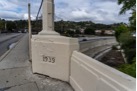 In 1939 a new bridge was dedicated. The Arroyo Seco Bridge was channelized in concrete, as was the entire LA River system following the 1938 flood. It’s an interesting piece of history. In 1939 a new bridge was dedicated. The Arroyo Seco Bridge was channelized in concrete, as was the entire LA River system following the 1938 flood. It’s an interesting piece of history. |
Good news! We’ll finish up the week nice and warm. The forecast for next week includes cloudy skies, cool temperatures and possible rain. When and how much are “up in the air!”
National Weather Service Reach her at suelkilpatrick@gmail.com.
Weather in the Foothills <<< Sue Kilpatrick added by CV Weekly on
View all posts by CV Weekly →