





Image by Mary O’KEEFE
California gets ready for a very wet winter by preparing now with the help of local agencies.
By Mary O’KEEFE
On Monday, Governor Gavin Newsom proclaimed a state of emergency in preparing for a predicted “historic El Niño storm season.”
The state of emergency “directs state agencies to begin protecting vulnerable communities, prepare roads and critical infrastructure, stage emergency supplies and help local partners reduce flood, landslides and coastal risks,” according to a statement from the governor’s office.
Also on Monday representatives from the California Dept. of Water Resources (DWR), California’s Natural Resources and California Governor’s Office of Emergency Services held a webinar to discuss the State’s proactive efforts in preparing for what may be a very wet winter.
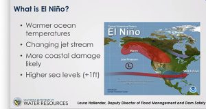
“To start off with, El Niño is a description of warmer than average sea temperatures in a specific region of the Pacific Ocean. These conditions alter climate patterns and can shape California’s water year,” said Laura Hollender, deputy director DWR, during the webinar.
El Niño is characterized by unusually warm ocean temperatures in the Equatorial Pacific, according to NOAA (National Oceanic and Atmospheric Administration).
The goal of the State is to get ahead of the possible flooding, beach erosion, strong surf and other issues that usually accompany an El Niño. California has experienced El Niño conditions in the past but this time the conditions are considered “historic” because of the warming of the ocean, which in the equatorial area has now surpassed 2 degrees Celsius, moving the designation of the El Niño to a very strong El Niño.
“El Nino is not one specific storm and does not by itself guarantee any specific storm or outcome. A warmer temperature increases the amount of moisture available to atmospheric rivers, potentially increasing the amount of rain any one storm delivers. It also moves the jet stream, potentially directing more storms toward the southerly part of the state,” Hollender said.
And there is the conundrum of El Niño – there is no guarantee of heavy rain.
“In the past, El Niños have given us quite a ride and caused large amounts of damage and have had a very high cost,” said Josh Willis, project scientist for the Sentinel-6 Michael Freilich and Sentinel-6B satellites, in an interview with CVW. “And this El Niño is one of the big ones.”
By increasing 2 degrees Celsius [which is equal to 35.6 degrees Fahrenheit] El Niño moved into the “very strong” category; however, the ocean is not done warming in that Niño area.
“El Niño will probably peak in November or December,” Willis said. “And the impacts from El Niño for us will probably peak in December or January, or maybe even into February. We’ll see an increasing impact from this El Niño for several months.”
El Niños cause the sea level to rise in the eastern Pacific, Willis said.
“So we’re looking at up to an extra foot of sea level increase because of this El Niño,” he said.
This is occurring in addition to the already rising coastal sea level.
Although scientists cannot guarantee this El Niño will bring rain, data from years past show that strong El Niño years can include wetter than average conditions. So the state is advising emergency responders and the public to pay close attention to warnings that would be issued by the National Weather Service [NWS], which is predicting “above average precipitation in California.”
Charts from NOAA and NWS show sea level spikes during major El Niño years.
“We have already seen recent damaging swells along the California coast. I would also like to note that king tides can exacerbate these conditions. Notably, the king tides are slated for November and December. These coincide with the holidays, so coastal communities should be especially vigilant during these times, even in the absence of storm events,” Hollender said.
“So the concern is real and that is why communities across California need to prepare today. And that is exactly why California is acting now. The State of Emergency proclamation announced by Governor Newsom gives the state the ability to move earlier, faster and with more focus to protect lives and support communities,” said Caroline Thomas-Jacobs, director of Cal OES.
This includes local agencies working with the state and emergency responders.
“We have been reached out to by the Office of Emergency Management for Los Angeles County. They are starting to coordinate with each of the different stations that may have concerns related to a heavy El Nino,” said Sgt. John Gilbert, Los Angeles County Sheriff’s Dept.-Crescenta Valley Station.
As stated, California has experienced El Niño conditions many times throughout recorded history; however, due to the changing climate it is expected that this time will be different.
“Even though we had a big El Niño in 1997, we’ve had almost 30 years of rising sea levels … so the impact of the high sea levels is going to be definitely bigger [effects] than it was in 1997, which is the last time we saw an El Niño of this size,” Willis said.
The warmer waters are not limited to possibly bringing a rainy season; much more is affected.
Next week CVW will focus on possible impacts of El Niño from the coast to the mountains, and how the community and individuals can be prepared.

Getting Ready for El Niño added by CV Weekly on
View all posts by CV Weekly →