
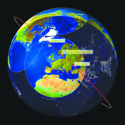
The image shows the position of the three satellites as they descend to the southeast, passing over the satellite ground station just outside of Toulouse, France, on January 28, 2009, at 23:39 UTC. As a result of maneuvers performed on January 26 and 27, Jason-1 has drifted well ahead of OSTM/Jason-2 and Topex/Poseidon. It is on its way to a new operational orbit on the other side of the Earth, 162 degrees ahead of OSTM/Jason-2.
Photo courtesy of JPL
By Mary O’KEEFE
Today, April 22, is Earth Day. It was in 1970 that Senator Gaylord Nelson created Earth Day as a way to highlight environmental awareness. There was no Environmental Protection Agency (EPA), no Clean Air Act and no Clean Water Act.
According to the EPA, back then it was legal to dump tons of toxic waste into streams, and factories had no regulations on how much toxic smoke they could pump into the air.
In December 1970 Congress authorized the creation of the new federal agency to deal with environmental issues, and the EPA was born.
Scientists began to look at how they could collect data on the environment. One of the missions, which opened the eyes of many oceanographers, was the Topographical Explorer (TOPEX)/Poseidon, a joint venture between CNES (France’s space agency) and NASA.
TOPEX/Poseidon was launched in 1992. Its mission was to send accurate data of the global measurements of sea levels. It mapped the global ocean topography.
TOPEX/Poseidon followed Seasat, which was launched in 1978 and was one of the earliest Earth-observing satellites. It was designed to test various oceanographic sensors and learn more about the Earth’s oceans. It operated for 105 days, measuring sea-surface winds and temperatures, wave heights, atmospheric liquid water content, sea ice features and ocean topography.
“The results were fantastic. The amount of data was more than we had in the preceding 100 years,” said Lee-Lueng Fu, chief scientist for TOPEX/Poseidon and senior research scientist at Jet Propulsion Laboratory.
He added that although Seasat only operated for a short time, the amount of data that was collected opened the eyes of oceanographers to the massive effect the oceans have on the planet. Prior to that mission scientists had only piecemeal information about the seas.
TOPEX/Poseidon was the perfect follow-up to Seasat, and its mission lasted for 13 years.
“[We found] an entirely new concept of the complexity of global oceans,” Fu said.
The satellite mission was able to measure sea levels with unprecedented accuracy, to better than 5 cm, and continuously observed global ocean topography, monitored effects of currents on global climate change, produced the first global views of seasonal changes of currents, monitored large-scale ocean features like Rossby and Kelvin waves, studied such phenomena as El Niño, La Niña and the Pacific Decadal Oscillation, mapped ocean circulation and produced the most accurate global maps of tides ever, according to JPL.
In addition, TOPEX/Poseidon mapped sea levels as well as the changing ocean temperatures.
When studying climate change scientists examine the changes surrounding excessive heat over the past 150 years.
“Scientists attribute the global warming trend observed since the mid-20th century to the human expansion of the ‘greenhouse effect’ – warming that results when the atmosphere traps heat radiating from Earth toward space,” according to NASA Global Climate Change.
“Over 90% of the [excess] heat is absorbed by the oceans,” Fu said. “Hypothetically, if we didn’t have the ocean the planet’s [temperature] would be 67 degrees Celsius [152.6 degrees Fahrenheit] and not habitable.”
Oceans also absorb one quarter of the Earth’s carbon dioxide. Carbon dioxide is the result of the burning of fossil fuels that mix with oxygen in the air. Carbon dioxide output increased after the Industrial Revolution.
The information gathered by TOPEX/Poseidon gave scientists enough accurate information to create models to predict how the temperatures in the oceans will continue to rise.
Sea level data is being collected and is a century-long project.
“Now we have more than 30 years of records. We have detected the speed of the level of rise. TOPEX [found] the rise to be three millimeters per year and now [with new technology] that level has risen to five millimeters per year,” Fu said.
The 1970s Earth Day commemoration ushered in whole new interests, methods and even a sense of urgency in Earth’s studies, and that exploration has continued and expanded.
“After the initial success [of TOPEX] I was able to convince the administration at the time to follow the mission of TOPEX/Poseidon with [another mission],” Fu said.
Those missions were the Jason series.
“Jason 1 was launched in 2001,” he said.
That was five years prior to the end of the TOPEX mission. Jason 1 mapped the sea level, wind speed and wave height for more than 95% of Earth’s ice-free ocean. It provided new information on ocean circulation and rising sea levels and enabled more accurate weather, ocean and climate forecasts.
Jason 1 was followed by Jason, 2, 3 and Sentinel 6. Each mission provided more accurate data to help scientists create models allowing them to predict the future of the oceans.
Fu added that none of this exploration could be done without the support from space agencies in other countries like France. Today there are many Earth science satellites from countries like India and China. Information is shared throughout space agencies.
The heightened awareness of Earth science that began in 1970 continues today and will continue into the future as scientists pore over new data that can share how the planet is changing.
Over 50 Years Celebrating Earth Day added by CV Weekly on
View all posts by CV Weekly →